Landslides
Introduction to landslides in North Carolina
The Department of Environmental Quality’s North Carolina Geological Survey (NCGS) has launched a new landslide website and GIS-based mapping tool to better inform communities about landslide hazards. NCGS, within the Division of Energy, Mineral, and Land Resources, worked with the National Environmental Modeling & Analysis Center at University of North Carolina Asheville on the project.
The Landslides in Western North Carolina Project website allows users to explore current and historical information about landslides in North Carolina. Users can access resources to help them plan for and build resilience to landslide hazards. The new “Western North Carolina Landslide Hazard Data Viewer” will make it easier for various audiences to access, interact with and understand landslide hazard data.
The publicly available website and viewer are designed for use by community planners, emergency management personnel, design consultants, educators and real estate professionals. NCGS’ currently published landslide inventory contains information on more than 4,500 landslides. Data is available for download and is updated as landslides occur in North Carolina.
The landslide team surveys and documents landslide locations and impact areas using a Geographical Information System (GIS) that combines satellite and aerial imagery, unmanned aerial vehicles and field work to produce the Data Viewer. The Viewer includes a current inventory of landslide points (where landslides started), landslide outlines (the approximate extent of individual slope movements) and landslide deposits (the extent of significant volumes of earth, debris and rock fragments that have accumulated due to past debris flows and debris slides, rock falls and rockslides), mapped and published by NCGS.
Learn more by visiting landslidesncgs.com.
Table of Contents - Landslide Information
 |
 |
| (Above) Boulders on the Blue Ridge Parkway from the April 24, 2003, rockslide near Potato Field Gap, northeast of Asheville. The 165-ton boulder is being broken down to fit into a dump truck |
(Above) Scar from the 1997 rockslide along I-40 in the Pigeon River Gorge. The rockslide closed the highway for more than 20 days. In this image, clean-up efforts have removed most of the debris pile, a retaining wall has been constructed and I-40 has been reopened. Landslides can be very small, like those on the side of a ditch, or they can be as large as mountainsides like this. This rockslide was caused, in part, by the nature of the underlying rock. Most rock formations have layers similar to a stack of books. If you tip a stack of books they will slide off each other just as tilted layers of rocks can slide off a mountainside. The layers of rock are planes of weakness where the landslide separates from the side of the mountain. Geologic maps show how these planes are oriented and the maps can be used for route planning. |

The trained eye of a geologist can discover hints that the land is currently moving and uncover clues as to where it has moved in the past. Evidence that the land is moving include cracks that appear when the land is slowly pulling apart from the hillside. These cracks are called tension cracks. With time, the ground on one side of the tension crack may slide downhill forming a scarp (see illustrations below). If the ground moves far enough, it will leave a mark called a scar. A fresh scar will usually have a lighter color and no vegetation compared to the surrounding slopes.

(Above image) Main parts of a general landslide

(Above image) This is where a debris flow, a type of landslide, was triggered in Henderson County by heavy rainfall from the remnants of Hurricane Francis in 2004. Tension cracks indicate areas on the ground have pulled away from the hillside. Scarps indicate areas that have already dropped down; with time, tension cracks in the pavement will likely become scarps.
Another clue that the land is moving is trees growing at an angle or with bent trunks as shown in the two images below. Trees growing on the side of a hill normally grow straight up. If the land is slowly moving downslope, the trees will lean, but keep trying to grow straight towards the sun. This process results in their bent growth pattern and indicates the trees are slowly sliding down the hill on top of the landslide. This should be a warning that the land may move substantially with the next large rainstorm.

(Above) -- Tree showing curved growth. The curved growth pattern (yellow line) indicates the tree is growing on top of a slowly moving landslide.
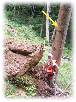
(Above) -- A landslide can carry a lot of debris. This debris flow took the bark off the tree 10 feet above the ground indicating the flow as about 10 feet deep at that point. It also carried the large boulder downhill, bringing it to rest next to the tree. A landslide can leave a trail of destruction along its path and a pile of debris at the end of its journey.
Hurricanes in the Mountains -- Hurricanes not only affect the coast, they can move inland and drop tremendous amounts of rain. A single hurricane can substantially affect a large area. If consecutive storms hit an area within a short period of time, the results can be devastating. Such an occurrence happened when the remnants of Hurricanes Frances and Ivan passed through the North Carolina mountains within a two-week time span in September 2004.

(Above) -- In 2004 the Peeks Creek Community in Macon County, North Carolina experienced one of the largest landslides to hit the North Carolina mountain region in decades. Tons of water, mud, rocks, trees and other debris traveled for more than two miles. The debris flow was 30 feet deep and 250 feet wide at some points and traveled downhill as fast as 33 miles per hour. (North Carolina Geological Survey staff geologist, lower-left corner of image for scale.)
The large amount of rain falling on steep, unmodified slopes in such a short period of time triggered the more than two-mile-long debris flow. Ivan dropped between 4 to 6 inches of rain, with higher elevations receiving 10 or more inches of precipitation. This rainfall was in addition to the remnants of Hurricane Frances that dropped 6 to 10 inches of rain, with many areas receiving greater than 10 inches. This landslide was most likely because of steep slopes, shallow soil and large amounts of rain. Mountain counties were hard hit by these back-to-back events with destruction to property and transportation routes throughout the region.

(Above) -- The Peeks Creek debris flow destroyed or damaged 15 homes, and five fatalities, including an unborn child, were reported. The debris flow pushed this two-story home 30 feet off its foundation. The piles of debris to the right of the house are the remnants of an adjacent house that was destroyed.

(Above) -- In a subdivision in Watauga County, one home was destroyed and eight others condemned for occupancy by landslides related to Hurricane Frances in 2004.

(Above) -- This landslide, caused by Hurricane Ivan in 2004, destroyed this home in Starnes Cove, Buncombe County. Photo courtesy of the Asheville Citizen-Times online edition.
References
North Carolina Geological Survey, 2005,When the Earth Moves, Randy Bechtel, editor: Information Circular 32: North Carolina Geological Survey, Raleigh, North Carolina, 24 p.
Varnes, D. J., 1978, Slope movement types and processes: In: Landslide Analysis and Control: In Schuster, R. L., Krizak, eds. Transportation Research Board Special Report No. 176, National Academy of Sciences, Washington, D. C., P. 11-33.
Contact Information
For additional information about landslide hazards in North Carolina, please contact Dr. David Korte with the NCGS Asheville Regional Office:
2090 U. S. Highway 70,
Swannanoa, North Carolina 28778.
828-296-4540
david.korte@ncdenr.gov